 |
| Shasta, lone and white as a winter moon |
3.5 miles loop, 1200 feet elevation gain
Difficulty: Moderate; some route-finding and rock scrambling necessary
Access: Paved road to trailhead, free parking
"As lone as God and white as a winter moon, Mount Shasta starts up sudden and solitary from heart of the great black forests of Northern California."
So wrote Joaquin Miller, a frontier poet, of the snowy and lonely Shasta. The second tallest and second southernmost stratovolcano of the Cascade Range, Shasta's massive cone is one of the most impressive sights in a state packed with them. Castle Peak, a low but rocky summit in the nearby Trinity Divide of Northern California's Klamath Mountains, provides one of the best front-row seats to this singular, ice-clad mountain. The route to the peak via Heart Lake hits beautiful views of two different lakes and three different volcanoes in just over three miles; the catch is that it takes a bit of route-finding and rock scrambling to find your way to this still relatively unknown but increasingly popular peak.
I hiked up to Castle Peak on a reasonably nice late October day with three friends. We set out from the Bay Area early in the morning, stopping for lunch at Wilda's Grill in Redding and setting up our campsite at the Sims Flat Campground before driving to the trailhead in the early afternoon. The easiest way to reach the trailhead from I-5 is to leave the interstate at exit 738 at the city of Mount Shasta, head west on West Lake St, turn left to go south onto Old Stage Road, turn left at the next intersection to head south on W A Barr Road, continue on W A Barr until crossing the Box Canyon Dam and then immediately turn left at the next intersection onto Castle Lake Road, which dead ends at the lake after making its way uphill into the mountains of the Trinity Divide. Although Castle Peak, the destination of our hike, is over 6600 feet high, the car had already done most of the work, shuttling us over a mile above sea level to the trailhead. Castle Peak, Heart Lake, and Castle Lake are located in Shasta-Trinity National Forest; currently no fee is charged for trailhead parking.
The parking lot had enough room for at least 20 cars and was close to full on that comfortable fall day. The trailhead was unmarked, to the left of the parking area. We started by following one of the many beaten paths down to the lakeshore for a view of Castle Lake, a large lake that filled a glacier-carved bowl. The bare granite of Castle Peak rose to the south; two forested ridges bound the lake on either side. Placards here noted Castle Lake's significance in the field of limnology: scientists from UC Davis began monitoring this lake in the 1950s in a study that has continued through today in the longest-running mountain lake research program in existence, making this one of the most well-researched aquatic ecosystems in the world.
 |
| Castle Lake |
We returned to the trail and followed it on a clockwise half-revolution of the lake. The trail crossed the lake's outlet stream and then delved into sparse woods on the eastern shore of the lake, beginning a gentle climb. The trail was rocky at times and we had to negotiate a large blowdown, but otherwise this stretch along the Castle Lake Trail was easy to follow. In half a mile, we had climbed above the southern end of the lake into an area of open rocks and low vegetation, just downhill of a saddle. Here, the Castle Lake Trail continued heading uphill towards the saddle, eventually leading to Little Castle Lake and Mount Bradley; we left the trail on one of the unmarked use paths that led to the right, heading uphill in the direction of Castle Peak. The trail to Heart Lake is unofficial, so there is not necessarily a "correct" path here; most of the trails lead uphill to Heart Lake. For the sake of the subalpine environment here, the Forest Service should construct an official trail to protect vegetation from the growing stampede of visiting hikers.
The path that we followed towards Heart Lake approached a picturesque pine perched over the Castle Lake basin, with Black Butte visible near the city of Mount Shasta and Mount Shasta itself just visible, poking out from behind the ridge east of Castle Lake. Black Butte, a steep cinder cone, was one of the more distinct geological features we noted on the hike.
 |
| Black Butte rises in the distance, Castle Lake in the foreground |
Although not an official trail, the route was well-worn and easy to follow as it climbed to the base of the east-west ridge of Castle Peak. At the base of the ridge, the trail turned towards the right and climbed up to a small gap; after passing through the gap, we came upon tiny Heart Lake, about a mile from the trailhead. The lake was mostly in the open, with just a few pines and some bushes displaying nice fall foliage on its shores. The lake was divided into two lobes by a rocky peninsula to form a heart shape, which was not readily apparent from the lakeshore.
 |
| Heart Lake |
We followed a path onto the rock that jutted into the lake and found a spectacular view of Mount Shasta reflected in the lake's calm waters.
 |
| Shasta and Shastina reflected in Heart Lake |
Hikers who aren't prepared for route finding or rock scrambling should turn around at this point and return to the trailhead. The path to Castle Peak became much harder to negotiate and navigate past Heart Lake. We pressed onward from the lake, following the path across the lake's small outlet stream, briefly skirting the lake's northern shore, and then continuing on a well-trod path across the mountain bench holding Heart Lake. A couple hundred yards further, the trail began a steep ascent up the ridge leading north from Castle Peak. Here, the trail was sometimes easy to lose; at times we had to whack our way through scrubby manzanita bushes. At times, the trail devolved into a rock scramble, requiring us to use our hands with our feet to ascend. After a short but fairly intense push, we arrived at the top of the manzanita-covered ridge. Castle Peak rose to our left; we decided to first check out the northern cliff-edge of the ridge, which was to our right. We made our way down overgrown social trails through thick manzanita to the very edge of the cliff, which provided an unparalleled view of Castle Lake's blue waters.
 |
| Shasta towers over Castle Lake |
Mount Eddy, blanketed in fresh snow, made a notable appearance to the north. At just over 9000 feet, Eddy is the tallest peak in the Klamath Mountains, and the tallest mountain west of I-5; indeed, its summit is over 1000 feet higher than any of the summits in Washington's Olympic Mountains, its only competition in height along the northwest coast. Despite all of these impressive descriptors, Mount Eddy gets no respect: Shasta, Lassen, Castle Crags, and Black Butte steal all the attention along this hike.
 |
| Mount Eddy |
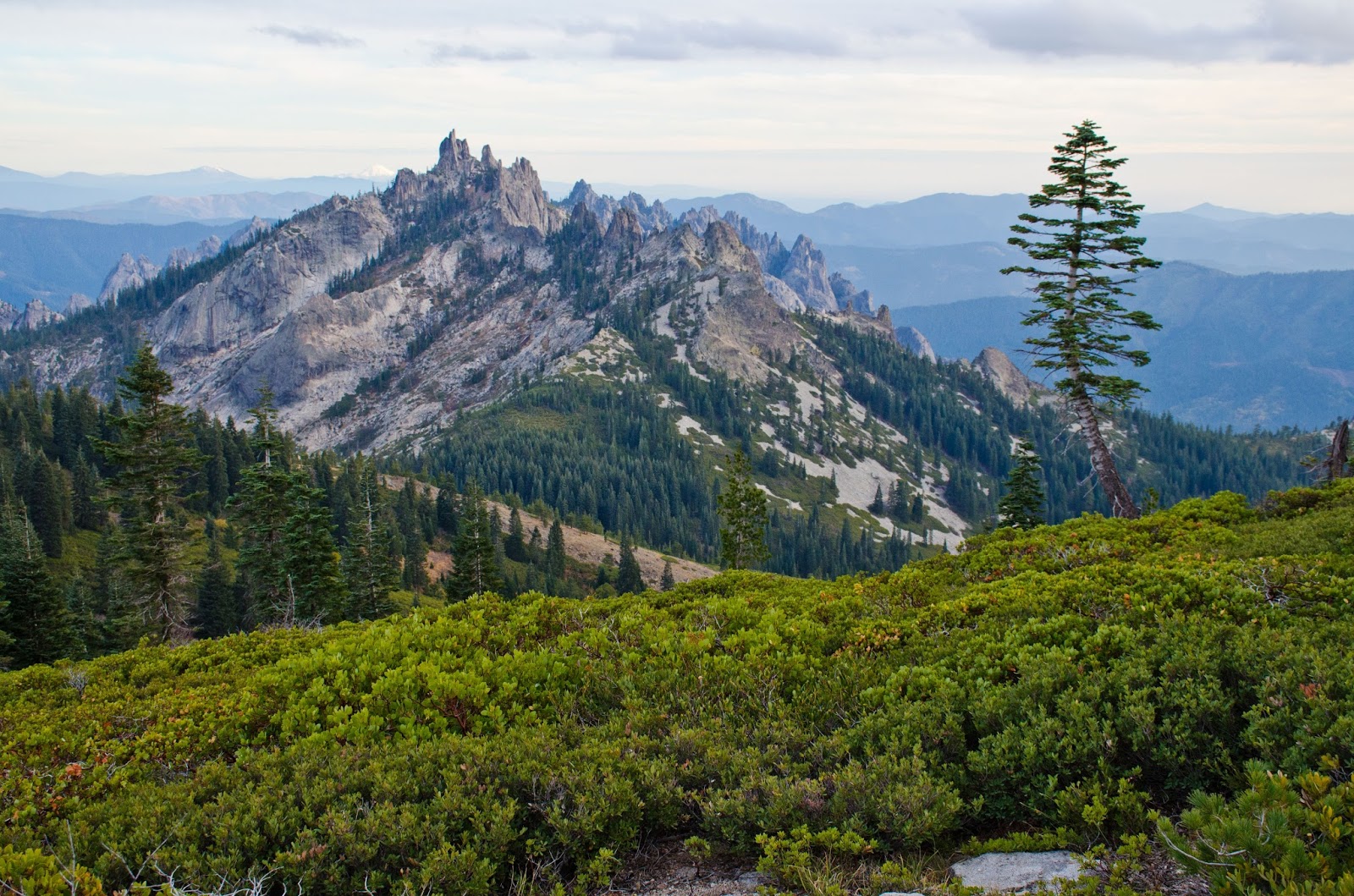
We followed the ridge south towards the summit of Castle Peak. There was sometimes a discernable trail and sometimes just a line of cairns marking the way through small boulder fields. Rock scrambling was necessary in multiple places and although the route was straightforward enough (we just followed the ridge), some judgment was necessary to pick reasonable routes up the mountain. The route was mostly out in the open, which meant that views of either Shasta or Eddy accompanied us throughout the uphill scramble.
As we continued upwards, views of the Castle Lake Basin opened up and we spotted both of the lakes that we had visited that day. Along with a handful of other lakes in the Trinity Mountains, these subalpine pools form the headwaters of the Sacramento River, one of the two major rivers that flows through California's Central Valley (the other is the San Joaquin, which flows from the alpine lakes of the High Sierra).
 |
| Shasta with Castle and Heart Lakes, from just below Castle Peak |
After hiking a little over a half mile from Heart Lake and scrambling across quite a few rocks, we arrived at the summit of Castle Peak. The summit area was broad and flat, with two windshelters and an unobstructed 360-degree view of the Trinity Divide and the other ranges of the Klamath Mountains. The most impressive aspect of the view was to the south: for the first time, we spotted the granite spires of the Castle Crags. Below the Crags, we spotted the Pacific Crest Trail winding its way to the south; the snowy summit of Lassen Peak, a massive plug dome forming the southern anchor of the Cascade Range, rose beyond.
 |
| Lassen Peak and the Castle Crags |
 |
| Castle Crags from Castle Peak |
To the north, we spotted Mount McLoughlin, a Cascade stratovolcano in southern Oregon.
 |
| Mount McLoughlin |
The many ridges of the Klamath Mountains rose to the north, south, and west. The mountains close in formed the subrange of the Trinity Divide. Mount Shasta lies at a junction between the Coast Ranges, of which the Klamath Mountains are a part, and the Cascade Range, which includes Mount Shasta itself.
 |
| Hazy blue ridges of the Klamath Mountains |
From the summit, we decided to make a lasso-loop of the hike rather than return by the same way we came. We followed the ridge heading east from the summit: a faint path led along the through the manzanita shrubs at the top of the ridge, occasionally fading out at talus slopes. The ridge route was entirely open as it followed the top of the granite cliffs rising above Heart Lake, providing excellent views along the descent. Heart Lake's heart shape became more apparent from this angle while Mount Shasta and Castle Crags provided a constant wow factor.
 |
| Shasta and the lakes |
 |
| Castle Crags from the descent along the Castle Peak east ridge |
The Crags were the site of one of the many battles between the Native Americans of Northern California and the Europeans who arrived in the 19th century. The Klamath clashed with gold prospectors at Castle Crags in 1855; the most well-known of the Northern California conflicts, however, occurred in the lava beds of the Medicine Lake Volcano, in the northeastern shadow of Shasta during the Modoc War. The end result of these conflicts was the confinement of tribes that had populated the Klamath Mountains and the desert east of Mount Shasta to small reservations in Northern California and Southern Oregon.
 |
| Castle Crags |
After taking in a final view of the Castle Crags from the ridgeline, we followed the social trail as it began to descend north from the ridge. At times the trail petered out, but we could now see the trail to Heart Lake below, so we made a beeline for the path up which we had come. During the descent, we saw the setting sun cast its final rays on Shasta, illuminating the snowcapped summit and the very top reaches of the Avalanche Gulch climbing route.
 |
| Last light on Shasta |
Once we returned to the path to Heart Lake, we made our way downhill until we returned to the official Castle Lake Trail and made quick work of the final half mile down to the parking lot. Although this hike is quite short- just a three and a half mile loop- be sure to allocate plenty of time for the hike. The rock scrambling and route finding on the ascent from Heart Lake to the top of Castle Peak and the ridgeline descent are all time consuming; be sure you have enough time to return to the trailhead by dark. Additionally, the excellent views along the trail demand constant attention; plan on at least three to four hours to really enjoy this hike.


No comments:
Post a Comment